Hi Bob,
Great question. I guess there's a number of different factors to consider that could lead to this.
In some cases, a really good ADS-B setup, pending location coupled with a good antenna can yield line of sight coverage out to 300nm or more, which actually equates to 555km+.
Then there is other instances where good tropospheric conditions can lead to ducting in the atmosphere which sees even further coverage, out into the 400nm range which is 740km+.
See Grahame's postings in this thread to understand more.
The Pacific is well known for sporadic ducting allowing abnormally high coverage consistently.
Also, one thing to keep in mind, is that for FlightRadar24 and PlaneFinder, these websites are fed by SBS radar feeders, or sharers. So whatever those sites display, is purely dependent on the information they're receiving from someone's antenna.
I do know that PlaneFinder specifically has a feature built into the software which estimates the track of an aircraft after it has lost signal for that aircraft from a feeder; the predicted tag stays on screen for quite a while before it drops off and even shows a 'continual' track. So with this estimation mechanism, maybe that's what you were seeing in the Pacific?
I also know that with PlaneFinder, when tracking an aircraft, the track line of the aircraft changes colour from bright red to dull red when the feeding ADS-B coverage is actually lost. That's how you can then tell it's a predicted track. The APP on Android behaves the same way. I'm not sure if FlightRadar24 has the same estimation functionality.
FlightAware is totally different to the others altogether. It's fed by the various FAA true radar coverage feeds directly, along with it's extremely accurate ability to estimate an aircraft's location, based on its last known height, speed, heading, flight plan route information, predicted weather for an area, ACARS transmissions, timetable scheduling and more. So with FlightAware, it displays an aircraft's position whilst it has radar contact, and then when it drops out of coverage the aircraft track displays as 'Estimated', which means it's no longer under radar coverage.
Occasionally an "Estimated" flight appears ahead of time before it's actually been truly radar identified. Then when the tag is radar identified you'll see the tag relocate itself back to where it "really" is.... In this case of a delayed pick up, one could assume that along the way, that particular flight has either experienced strong headwinds, a course change due ATC or weather and didn't keep up with it's estimation time.
On comparing observations between what a typical amateur ADS-B receiver can yield in the YSSY basin in comparison to what is truly shown by the radar feed on FlightAware, I've noticed that in most cases radar coverage tends to extend further than the theoretical range of the SBS boxes, or at least the capable range of the majority of Sydney based SBS feeds or sharers. Which basically means, I can see a solid pick up of an aircraft on FlightAware when an aircraft is radar identified, before it's actually identified on PlanePlotter by any amateur feed or sharer... Usually good to know when to expect something is going pop up on my own feed very shortly

I do know however, that overall, ADS-B provides better surveillance in fringe areas of radar coverage as ADS-B does not have the siting limitations of radar. Its accuracy is more consistent throughout the range.
With regards to the coverage of our Australian Based amateur ADS-B sharers who feed PlanePlotter for example; as at today, and going with the scenario that every sharer is capable of yielding a consistent coverage range of 250nm from their location across 360 degrees circumference, this predicted chart shows how well covered Australia is for amateur ADS-B feeding. Of course, some sites wouldn't be capable of producing 360 degree 250nm range, and others might exceed that, but in any case it's still a pretty good visual representation. This capable coverage should also be quite consistent for FlightRadar24 and PlaneFinder too, as in most cases a lot of the PlanePlotter feeders also feed those third party websites. We like to share the love.
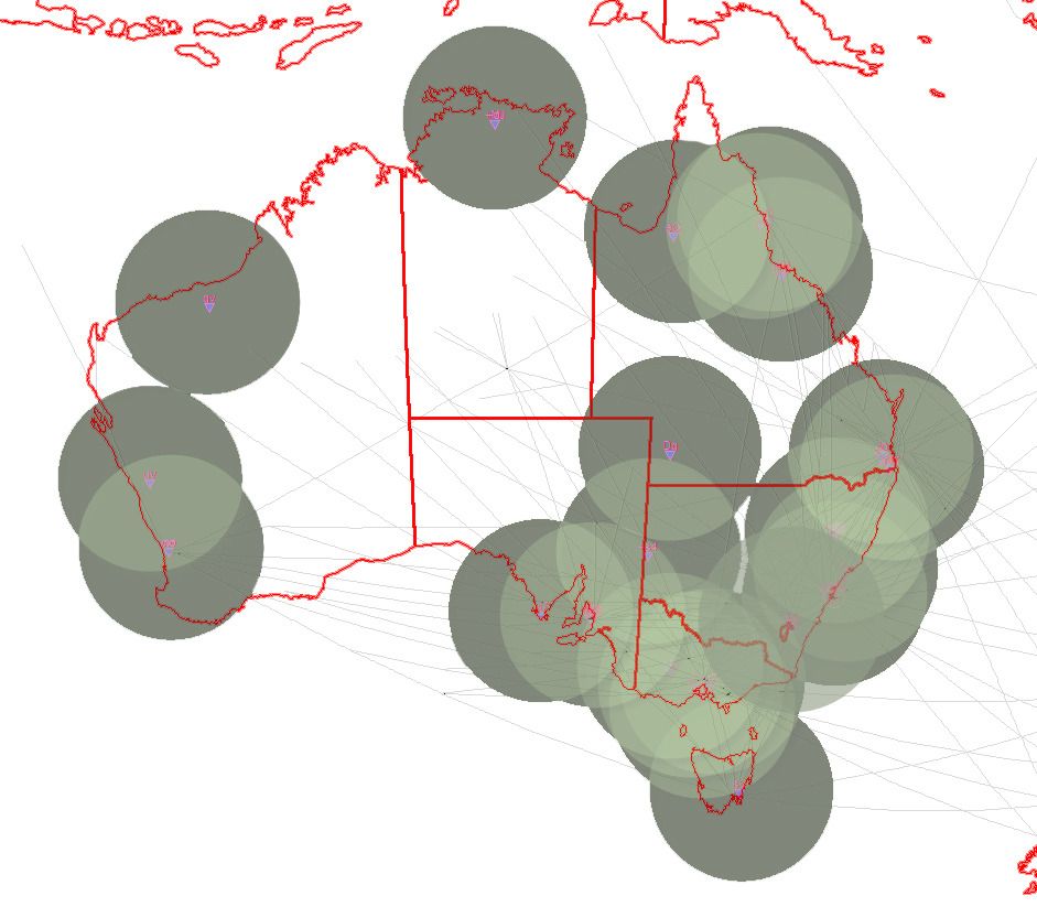
We also recently had a sharer based in Alice Springs which helped cover that Central Australia gap quite nicely. But sharers and feeds change all the time. Some don't feed 24/7, some are only available on weekends or after work, and others move from time to time depending on whether it's a permanent setup or not. It's quite interesting to see. Of note, there are sharers in Honolulu too, that could be aiding the pacific tracks you're seeing.
Anyway, those are just some of my thoughts based upon my own observations over 1 day, compared to the experience that others in this field have
No doubt others will have some more technical reasons to share.
Might you be in Sydney in late November Bob? Been a while since we've caught up!